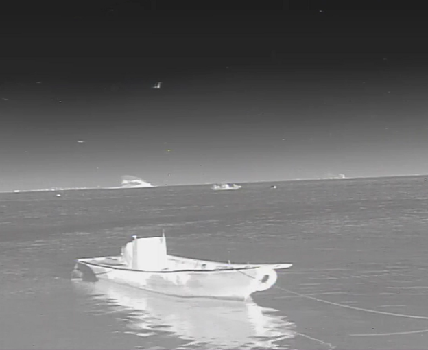
Not affected by rain, foggy weather, not affected by the reflection of the sunlight on the sea surface during the day, the interference of searchlight light at night, which is currently other visible light, micro-light, laser night vision and other security monitoring equipment does not have.
Therefore, infrared thermal imaging technology is efficient and practical in the marine environment to meet the following needs: Port, waterway and coastal security, maritime security, maritime illegal entry detection, maritime law enforcement, anti-piracy and threat detection, fishing fleet protection, ship tracking and observation, search and rescue operations and environmental protection. By employing infrared imaging solutions, this technology becomes indispensable in practical applications. Even objects that cannot be detected by radar systems (e.G. Sailboats, wooden boats and floating objects) can be detected using infrared thermography.
Maritime security faces more diverse difficulties than ever before, including law enforcement, search and rescue, water operations, harbour security, hazardous materials inspection, natural disaster monitoring, anti-poaching, and more. The changing maritime environment places extreme demands on mariners, and using good equipment is often the most effective solution. Everything you see in everyday life releases thermal energy called "heat signatures", which can be seen with thermal imaging as long as there is even the slightest temperature contrast between the object and its background, creating a heat signature.
Handheld thermal imaging cameras can see what the human eye cannot, they see heat and do not rely on light to create an image, they work well at night, and they can often observe targets at long distances, improving night time observation, and thermal imaging cameras are able to track victims and rescuers in the water.
When a person falls overboard during a maritime search and rescue operation, the head of the person is often the only visible part of the body. Shown on video as a white or red "head-shaped" image against a black or dark grey background, the head is clearly visible as it emits much more heat than water. This effect can be achieved both day and night, enabling 24/7 response.
Navigating a cruise ship in open water can be challenging. Navigating in ice-covered waters is even more difficult and dangerous. Shipping companies are increasingly concerned about the safety of ice-class tankers when navigating in waters where the temperature is below 0°c. Thermal imaging cameras are able to detect ice in the sea at long distances, thus avoiding collisions.
Portable operation, long battery life, stable operation, no degradation of image quality for long time use, compact and easy to carry, easy to operate buttons.
Fine image using 12μm detector with exatimes infrared movement, digital zoom up to 8 times, fine image, clear details;
Thermal imaging cameras can also be used in outdoor night vision, animal observation, jungle exploration, sailing, law enforcement patrol and many other areas.
Laser distance measuring
Laser distance measurement is to use a laser as a light source for distance measurement. According to the way the laser works, it is divided into phase lasers and pulse lasers. Phase lasers are characterized by high accuracy, and pulsed lasers measure long distances.
Laser ranging technology is widely used in the sea:
1. Marine measurement: Laser ranging technology can be used to measure the depth, flow rate, temperature and other parameters of seawater, which is of great significance for marine scientific research, marine environmental protection, marine resources development and other aspects.
2. Marine navigation: Laser ranging technology can be used to measure the distance and angle between the ship and the target object, thus helping the ship to carry out accurate navigation and positioning.
3. Marine engineering: Laser ranging technology can be used to measure the position and depth of undersea terrain, undersea pipelines, undersea cables, etc., which plays an important role in the construction and maintenance of marine engineering.
4. Marine resources exploration: Laser ranging technology can be used to measure the distribution and reserves of seabed oil, natural gas and other resources, which is of great significance to the development and utilization of marine resources.
5. Marine disaster monitoring: Laser ranging technology can be used to monitor waves, tsunamis and other marine disasters dynamic changes, timely warning and prevention of disasters.
